Log in
All resources
Create a design
11,660 Free Images of Old Map
bibliothèque nationale de france
maps of spain by tomas lopez
joan blaeu
baroque
copper engraving print
british library
maps from university of amsterdam special collections
atlas der neederlanden
copperplate print
special collections of the university of amsterdam
details of old maps of düsseldorf
rheinpark golzheim
atlas maior, vol 5 (england) - joan blaeu, 1667 - bl 114.h(star).5
17th-century maps of kent
atlas maior, vol 5 (england) - joan blaeu, 1667 - bl 114.h(star).5
17th-century maps of cumberland
atlas maior, vol 9 (italy) - joan blaeu, 1667 - bl 114.h(star).9
1667 maps of italy
atlas maior, vol 5 (england) - joan blaeu, 1667 - bl 114.h(star).5
17th-century maps of dorset
atlas maior, vol 5 (england) - joan blaeu, 1667 - bl 114.h(star).5
17th-century maps of county durham
orientalist painting
old maps of dakar
nouvelle géographie universelle, vol. i
old maps of naples
nieuwe en beknopte hand-atlas (1754)
old maps of curaçao
old maps of westphalia
bindenschild
prints by mario cartaro
old maps of basilicata
maps from university of amsterdam special collections
atlas der neederlanden
maps from university of amsterdam special collections
atlas der neederlanden
cartes generales de toutes les parties du monde (1658)
maps by guillaume sanson
1762 maps of north america
maps by tomas lopez
john rocque's 1746 map of london
old and new london (book)
old maps of veliky novgorod
maps of velikiy novgorod
the turkish empire in europe, asia and africa (1752)
maps of the history of turkey
gemeente atlas van nederland - north brabant
old maps of veghel
old maps of freiburg im breisgau
baroque
a voyage to abyssinia, and travels into the interior of that country, executed under the orders of the british government in the years 1809 & 1810
john outhett
siege of groenlo 1627
county of zutphen
the history of barbados; comprising a geographical and statistical description of the island (1848) by robert h. schombourgk
old maps of barbados
siege of coevorden 1592
old maps of coevorden
atlas - voyage pittoresque à l'île-de-france, au cap de bonne-espérance et à l'île de ténériffe (1812) by milbert
maps from the mechanical curator collection
engravings by matthäus merian
baroque
orientalist painting
old maps of dakar
details of old maps
michael burghers
maps from university of amsterdam special collections
atlas der neederlanden
old maps of whole wales (alone)
description de l'universe
1680s maps of baden-württemberg
description de l'universe
engravings of topographia bohemiae moraviae et silesiae
baroque
merian helvetiae, rhaetiae et valesiae
baroque
terrae sanctae tabula by guillaume delisle (1763)
eran laor cartographic collection
maps from university of amsterdam special collections
atlas der neederlanden
maps from university of amsterdam special collections
atlas der neederlanden
old maps of the balearic islands
maps of spain by tomas lopez
old maps of st. augustine, florida
john white (colonist and artist)
maps of haarlemmerhout
old maps of haarlem
atlas - voyage pittoresque à l'île-de-france, au cap de bonne-espérance et à l'île de ténériffe (1812) by milbert
maps from the mechanical curator collection
the turkish empire in europe, asia and africa (1752)
historical maps of adana
details of old maps, defaced
maps of erzurum province
encyclopédie méthodique - géographie physique
ambroise tardieu
topographia austriacarum (merian)
baroque
old maps of syracuse
pierre-adrien pâris
parts of old maps of hamburg
maps of hamburg-sternschanze
maps by nicolaes visscher i
atlas van der hagen
hakodate city central library
maps by takeshiro matsuura
old maps of the dutch east india company
1705
old maps of brabant
old maps of leuven
old maps of vardø
guillaume sanson
old maps of galicia (spain)
1834 in galicia (spain)
topographia bohemiae moraviae et silesiae (merian)
baroque
nicolaas samuel crucquius
old maps of delfland
plantae yucatanae. (regionis antillanae)
1903 in yucatán
maps of spain by tomas lopez
old maps of castile and león
maps of spain by tomas lopez
old maps of extremadura
old maps of south africa
maps of transvaal
nouvelle géographie universelle, vol. xii
old maps of saint-louis (senegal)
maps from the earth and its inhabitants, vol. iv
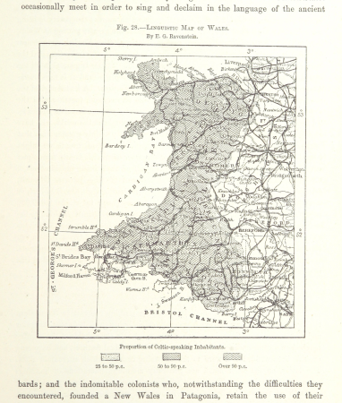
linguistic maps of wales
maps from the earth and its inhabitants, vol. xiv
19th-century maps of borneo
old maps of southeast asia
philips galle
old maps of the principality of minden
1840s maps of north rhine-westphalia
gemeente atlas van nederland - north brabant
old maps of breda, netherlands
topographia bohemiae moraviae et silesiae (merian)
baroque
gemeente atlas van nederland - overijssel
old maps of kampen, netherlands
engravings by matthäus merian
baroque
old maps of geraardsbergen
atlas van loon
maps of spain by tomas lopez
old maps of extremadura
maps of spain by tomas lopez
old maps of castile and león
maps of spain by tomas lopez
old maps of castile and león
maps of spain by tomas lopez
1783 maps of spain
maps from géographie illustrée de la france et de ses colonies
orientalist painting
old maps of the tsardom of russia
national coat of arms of russia
old maps of vardø
guillaume sanson
1800s maps of egypt
maps by john cary
johann caspar ulinger
old maps of zürich
maps by takeshiro matsuura
old maps of ezo
nicolaas samuel crucquius
old maps of delfland
reisebeschreibung nach arabien und andern umliegender ländern
old maps of turkey
topographia bohemiae moraviae et silesiae (merian)
baroque
maps of spain by tomas lopez
1783 maps of spain
maps of spain by tomas lopez
old maps of castile and león
maps of spain by tomas lopez
1783 maps of spain
maps of spain by tomas lopez
1783 maps of spain
description de l'universe
old maps of greece
historical maps of baía de todos os santos
maps by willem and johannes blaeu
maps from the earth and its inhabitants, vol. xiii
maps of telegraph lines
old maps of south africa
emil holub
description de l'universe
old maps of karpathos
maps in the library of congress
1877 maps of the united states
18th-century maps of panama
war of jenkins' ear
eran laor cartographic collection
johannes van den aveelen
de wikisource book leaflet
de nordseeküste (karten)
old maps of southeast asia
maps by gerard valck
gemeente atlas van nederland - overijssel
old maps of vollenhove
greifswald in the 17th century
old maps of greifswald
historical maps of baía de todos os santos
maps by willem and johannes blaeu
old maps of north holland
zaandam
old maps of whole wales (alone)
1640s maps of wales
8801 - 8900 of 11,660
Next page
/ 117


![T Hoogh-Heemraetschap vande Uytwaterende Sluysen in Kennemerlant and West Frieslant / [Johannes Douw], Isaak Tirion, [1756]](https://cdn.creazilla.com/illustrations/10000560278/t-hoogh-heemraetschap-vande-uytwaterende-sluysen-in-kennemerlant-and-west-frieslant-johannes-douw-isaak-tirion-1756-md.jpg)
![T Hoogh-Heemraetschap vande Uytwaterende Sluysen in Kennemerlant and West Frieslant / [Johannes Douw], Isaak Tirion, [1756]](https://cdn.creazilla.com/illustrations/10001440533/t-hoogh-heemraetschap-vande-uytwaterende-sluysen-in-kennemerlant-and-west-frieslant-johannes-douw-isaak-tirion-1756-md.jpg)


![T Hoogh-Heemraetschap vande Uytwaterende Sluysen in Kennemerlant and West Frieslant / [Johannes Douw], Isaak Tirion, [1756]](https://cdn.creazilla.com/illustrations/10000841147/t-hoogh-heemraetschap-vande-uytwaterende-sluysen-in-kennemerlant-and-west-frieslant-johannes-douw-isaak-tirion-1756-sm.webp)


![Map of the craftsmanship of the Old and New Streuyt / A. Steyaart invenit; I. Stemmer's sculpsit; I. Shutters fecit cum aqua forti, Romeyn de Hooghe, [1701]](https://cdn.creazilla.com/illustrations/10000536041/map-of-the-craftsmanship-of-the-old-and-new-streuyt-a-steyaart-invenit-i-stemmers-sculpsit-i-shutters-fecit-cum-aqua-forti-romeyn-de-hooghe-1701-md.jpg)
![T Hoogh-Heemraetschap vande Uytwaterende Sluysen in Kennemerlant and West Frieslant / [Johannes Douw], Isaak Tirion, [1756]](https://cdn.creazilla.com/illustrations/10000976652/t-hoogh-heemraetschap-vande-uytwaterende-sluysen-in-kennemerlant-and-west-frieslant-johannes-douw-isaak-tirion-1756-md.jpg)


![Sinus Omnium Sanctoru[m] [Cartográfico], Joan Blaeu, between 1664 and 1665](https://cdn.creazilla.com/illustrations/10000412512/sinus-omnium-sanctoru-m-cartogr-fico-joan-blaeu-between-1664-and-1665-md.jpg)


![Sinus Omnium Sanctoru[m] [Cartográfico], Joan Blaeu, between 1664 and 1665](https://cdn.creazilla.com/illustrations/10000943692/sinus-omnium-sanctorum-cartogrfico-joan-blaeu-between-1664-and-1665-sm.webp)

![Wallia principatus, vulgo Wales. Serenmo Domino Carolo, Magnae Britanniae, etc. principi Joh. Blaeu / [Excudit J. Blaeu.], 1645](https://cdn.creazilla.com/illustrations/10001591803/wallia-principatus-vulgo-wales-serenmo-domino-carolo-magnae-britanniae-etc-principi-joh-blaeu-excudit-j-blaeu-1645-sm.jpg)